project-proposal-2025
TerraCheck: Smart Excavation Risk Assessment Platform
Abstract
With the 2032 Olympics looming, Brisbane is poised for enormous urban growth in the coming years. Judging the viability of projects with deep digging and excavations presents itself as a challenge for city planners, architects, developers, and excavators. TerraCheck is a powerful and scalable underground utility risk assessment application that offers a new generation planning solution to prevent the threat of accidental damage to gas pipelines, electricity cables, and water mains - accidents that can be unsafe and problematic from a legal and monetary point of view.
The system provides map-based excavation risk check powered by simulated utility data-driven capability and rule-based geospatial risk engine with future potential to integrate real-time GIS data and live council feeds. It has provision for definitions of dig zones, input of excavation depth, and real-time alert and risk reporting - enabling intelligent, proactive, and compliant excavation planning.
Author
Name: Tarushi Gera
Student Number: 48242204
Functionality
Features
-
Set Up User Profile, Role Selection & Dashboard: Users can register an account and select their industry role at onboarding. The system offers a dashboard interface to create new excavation projects or manage completed ones.
-
Interactive Map Interface: A map interface for users to draw custom dig zones and input excavation details.
-
Risk Engine: A rule-based engine evaluates each dig zone by comparing its geometry and depth against the location of underground utilities to detect potential conflicts.
-
Severity Scoring & Safety Suggestions: The system calculates the risk severity and provides intelligent suggestions using parameters such as buffer region, utility type, and excavation depth proximity.
-
Standards Alignment: Safety recommendations and calculations are aligned with guidelines from BYDA and Safe Work Australia’s trenching standards.
-
Report Generation: Users can download detailed PDF reports including project metadata, utility conflict detection, severity levels, and tailored safety recommendations.
-
Quick Safety Checks: The application supports a “Quick Check” feature, which allows users to perform risk assessments without logging in; results are not stored.
-
Responsive Web App: TerraCheck is built as a fully responsive web application, ensuring usability across devices.
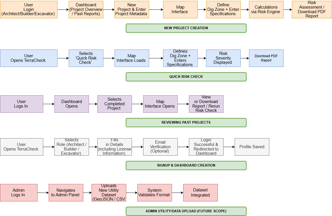
Workflows
Following is a diagrammatic representation of the possible workflows and user scenarios -
Scope
The MVP aims to include:
- A responsive, web-based user dashboard for managing excavation projects.
- An interactive map component (built using JavaScript libraries such as Leaflet.js) that allows users to define custom dig zones.
- User input for excavation specifications (e.g., depth) to enable automated risk assessment.
- A rule-based geospatial risk engine that:
- Compares dig zone geometry against known underground utility data.
- Flags zones that intersect with utilities or exceed safety buffer thresholds.
- Colour-coded severity indicators (Low/Medium/High Risk) based on calculated proximity and depth.
- Downloadable PDF reports that include dig zone details, detected utility conflicts, severity scores, and recommended safety actions.
- A “Quick Check” mode that allows users to perform a risk check without logging in & saving the results.
- Support for static underground utility datasets in standard formats such as GeoJSON or CSV.
Quality Attributes
In my opinion, Modularity, Reliability, Extensibility & Availability are the most important quality attributes for TerraCheck:
1. Modularity
A system is said to be modular when each of its components can function independently. TerraCheck is planned to have five components – dashboard, map interface, risk engine, PDF report generator, and dataset loader. All of these components will be designed independently, allowing the system to be tested, extended, debugged, and scaled without causing breakages in other parts of the code, thereby reducing complexity.
Modularity will be achieved by using a microservice-based architecture, where each module is loosely coupled and discrete but communicates through well-defined interfaces. If development time or resources are constrained, ensuring strong modular boundaries will still be a top priority, even higher than polishing UI features or implementing advanced data inputs.
2. Reliability
Since TerraCheck is a safety and hazard-prevention tool it is important that its reliability is never compromised in terms of its safety-critical calculations. Users must be able to trust the system to return accurate results based on excavation depth and proximity to underground utilities using deterministic logic based on buffer zone and depth comparison.
Reliability holds the second highest priority even at the cost of availability or UX since the accuracy of risk results must never be compromised. It can be tested using unit and integration testing for validation of output under several scenarios including known test cases for consistent output.
3. Extensibility
TerraCheck has immense scope for future features such as real-time GIS API integration, ML-driven risk scoring, user account management, and admin utility uploads to help evolve the tool into a SaaS product.
The risk engine will use pluggable rule modules, allowing additional excavation guidelines or industry-specific policies to be added easily. Utility datasets will be parsed using standard formats to make swapping or expansion easy in future versions.
4. Availability
End-users must be able to access TerraCheck on demand from their devices at any time or location. While real-time uptime monitoring is not included in the MVP, the system will be hosted on AWS cloud-based platform, which inherently provides high availability, fault tolerance and scalability.
Additionally, the “Quick Check” mode will enable users to perform risk assessments without logging in, making it highly accessible for field usage.
Note: Interoperability is a potential future quality attribute when sourcing utility datasets from the council or exporting generated reports.
Evaluation
Modularity
- Review whether each component functions independently without relying on other modules.
- Replace or refactor one component, such as the PDF template or utility dataset format and verify that the system continues to function without requiring changes elsewhere.
- Ensure that the code structure is loosely coupled and that each feature can be tested in isolation.
Reliability
- Create test cases for sample dig zones to verify that severity scoring is deterministic and accurate.
- Perform edge case tests for both populated and empty utility regions to further define correctness.
- Run identical inputs multiple times over a fixed duration and confirm that the output remains consistent and reliable.
Extensibility
- Add a new excavation rule and plug in a different utility dataset to verify that the system continues to function correctly.
- Measure the time and LOC required to integrate the new rule.
- Evaluate extensibility based on the level of effort: lower time and LOC indicate better extensibility.
Availability
- Deploy the application to a cloud platform and monitor uptime and downtime over a 48-hour period.
- Load test the application with multiple concurrent sessions and projects to verify responsiveness under load.
- Use the “Quick Check” mode to test accessibility and functionality without requiring user login.